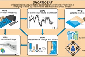
SHORMOSAT
In SHORMOSAT, we will use a state-of-the-art hydrid model of coastline evolution (LX-Shore) and adapted data assimilation techniques based on more than 35 years of coastline data from satellite imagery. The project aims to understand the evolution of the coastline, the main driving processes and forcings, and to explore the future of beaches where the accommodation space at the back is limited, for example, by coastal structures.
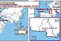
This theoretical framework will be applied to seven carefully selected national and international sites, distributed over three continents and monitored by our consortium and international collaborators. These sites are representative of the three most common sandy shore environments in the world:
(i) Bay beaches (O(1 km)) with varying degrees of exposure to incident waves and sediment bypass off groynes or rocky headlands,
(ii) wave-dominated deltas (O(10-100 km)),
(iii) large sedimentary barriers (O(100 km)) interrupted by tidal or estuarine mouths.
We will improve the LX-Shore model and extend its scope by including the sediment bypass of obstacles, sediment sources, a beach profile evolution module and a new wave module. More globally, SHORMOSAT will shed new light on past and future multi-decadal coastline evolution and possible trajectory changes in the context of climate change and increasing anthropogenic pressures with major implications for society and coastal zone management, by developing and applying advanced image processing techniques.
2022: SHORMOSAT
Head of CEREGE: E.J. Anthony
Understanding and predicting the evolution of the coastline, the main driving processes and forcings
Partners :
EPOC (PI B. Castelle), project leader
BRGM (PI D. Idier)
CEREGE